When ice lets go
Glacier retreat does not only take ice away. It destabilises slopes, fills new lakes and loosens frozen rock, and the disasters it causes strike fast.
Where it happened
Red dots: the events described on this site. Click one to read more. The lakes map shows the 1,192 lakes that formed where glaciers retreated.
Ice avalanches and glacier collapse
Steep glaciers can break off. Warming changes where and how.
Hanging glaciers cling to steep faces. Many of them are cold, frozen to the rock beneath. As the Alps warm, meltwater can reach the bed and loosen that grip, and whole sections can fail at once, as on the Altels in 1895.
Glacier tongues that end on steep ground calve blocks of ice, like the Allalin above Mattmark. And a glacier can be pushed beyond its limits from outside: in 2025 rockfall debris loaded the Birch Glacier until it collapsed onto Blatten.
Radar and GPS now watch dozens of unstable glaciers in Switzerland. When a glacier accelerates towards failure, its speed often follows a predictable curve, which is how the 2017 collapse on the Weissmies was forecast to the day.
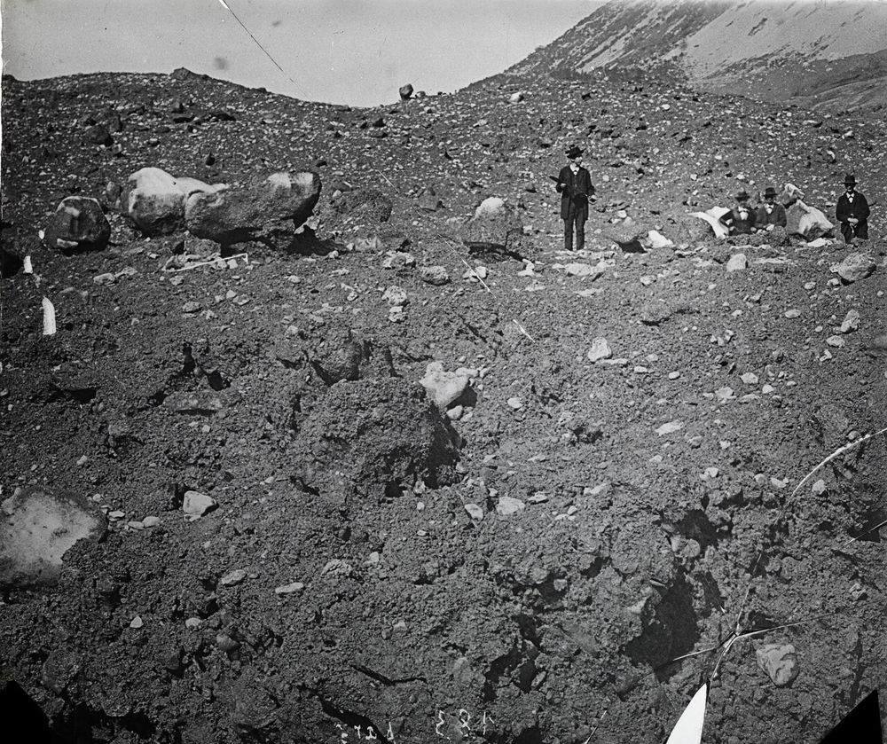
The Altels ice avalanche
A cold hanging glacier broke off the Altels in one piece: about 4 million m³ of ice, the largest ice fall ever observed in the Alps.
Mattmark
The tongue of the Allalin Glacier broke off above the Mattmark dam construction site and killed 88 workers.
A predicted collapse
Radar showed the Trift Glacier on the Weissmies speeding up to 2 m a day. The village was evacuated, and the ice fell the next morning.
Blatten
Rockfalls overloaded the Birch Glacier until it collapsed. Rock and ice buried most of the village of Blatten, which had been evacuated nine days before.
Glacier lake outbursts
Retreating ice leaves lakes behind. Some are held back by ice or loose moraine.
Since 1850 about 1,200 lakes have formed in the areas Swiss glaciers left behind; 987 of them still existed in 2016. Most are small and harmless. Some are dammed by ice or by unstable moraine, and can drain suddenly.
An outburst can release millions of cubic metres of water in hours, and on steep ground it can pick up debris and become a debris flow. The Giétro flood of 1818 is the historical worst case; Grindelwald in 2008 and Lenk in 2018 are recent ones.
Engineering helps: tunnels and channels keep lakes low at Grindelwald and on the Plaine Morte. But new lakes keep forming, 180 of them in the decade to 2016 alone.
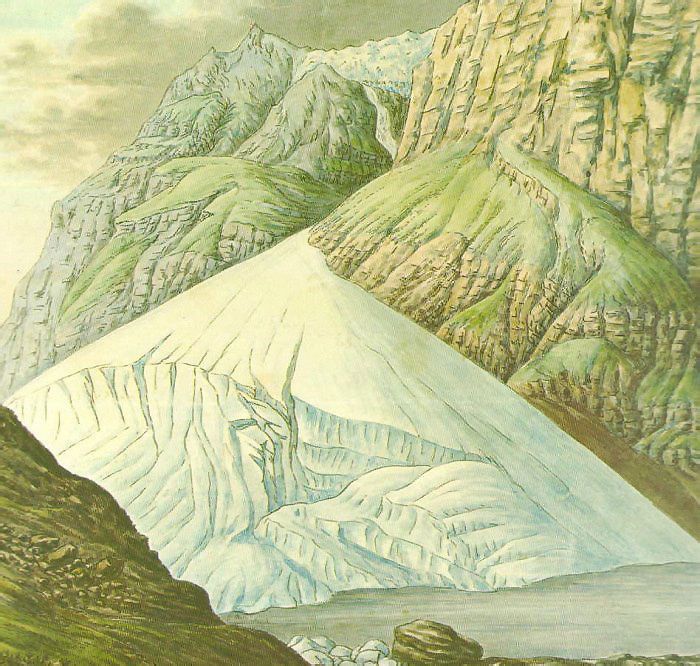

The Giétro flood
Ice from the Giétro Glacier dammed the valley. When the dam gave way, 20 million m³ of water reached Martigny in 90 minutes.
The Grindelwald glacier lake
A lake on the collapsing tongue of the Lower Grindelwald Glacier drained suddenly in 2008. A tunnel through the rock now keeps it low.
Lac des Faverges empties
A lake on the Plaine Morte Glacier drained through the ice in 24 hours and flooded the village of Lenk.
Rockfall, landslides and debris flows
Glaciers and permafrost hold mountains together. Take them away and slopes move.
Glacier ice supports the valley walls around it. When the glacier thins, the slopes lose that support and can start to slide. This is called debuttressing, and the Moosfluh above the Aletsch Glacier is the textbook Swiss example.
Higher up, permafrost, ground that stays frozen all year, acts as a cement in steep rock faces. As it thaws, rockfalls become more frequent, often in places that were considered safe.
When a rock avalanche falls onto ice, it can take the ice and meltwater with it and turn into a fast debris flow, as at Piz Cengalo in 2017.
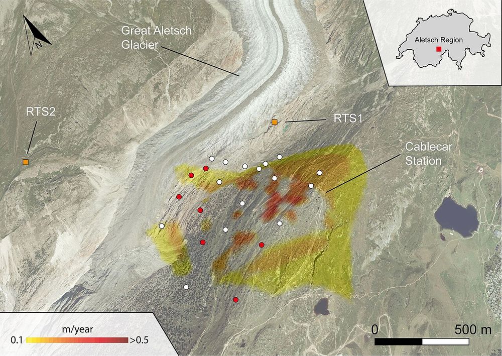

Moosfluh starts to slide
When the Aletsch Glacier thinned below a critical level, the valley flank it had been holding up accelerated to 80 cm a day.
Piz Cengalo and Bondo
Three million m³ of rock fell on a small glacier, took its ice with it and turned into a debris flow that reached the village of Bondo.
Piz Scerscen
About a million m³ of rock and ice fell from Piz Scerscen and ran some 5 km down the Tschierva Glacier.
Sources
- Faillettaz et al. (2011). Climate warming and stability of cold hanging glaciers: lessons from the gigantic 1895 Altels break-off. arxiv.org/abs/1101.5062
- Petley, D. (2025). The 28 May 2025 catastrophic failure of the Birch Glacier. The Landslide Blog, Eos. eos.org/thelandslideblog/blatten-birch-glacier-5
- Wikipedia. 2025 Blatten glacier collapse. en.wikipedia.org/wiki/2025_Blatten_glacier_collapse
- Mergili et al. (2020). Back calculation of the 2017 Piz Cengalo–Bondo landslide cascade with r.avaflow. NHESS 20. nhess.copernicus.org/articles/20/505/2020/
- Huss, Linsbauer & Naegeli (2025). Swiss Glaciers. State, projections and significance. Swiss Academies Factsheets 20(2). doi.org/10.5281/zenodo.14866776
- Ancey et al. (2019). Hydraulic reconstruction of the 1818 Giétro glacial lake outburst flood. Water Resources Research. agupubs.onlinelibrary.wiley.com/doi/full/10.1029/2019WR025274
- Werder et al. (2010). Hazard assessment investigations in connection with the formation of a lake on the tongue of Unterer Grindelwaldgletscher. NHESS 10. nhess.copernicus.org/articles/10/227/2010/
- Dodis – Diplomatic Documents of Switzerland. The catastrophe of Mattmark in 1965. www.dodis.ch/en/catastrophe-mattmark-1965
- swissinfo.ch (2015). The Mattmark disaster: a dramatic page in Swiss history. www.swissinfo.ch/eng/society/50th-anniversary_the-mattmark-disaster--a-dramatic-page-in-swiss-history/41627972/
- Mölg et al. (2021). Inventory and evolution of glacial lakes since the Little Ice Age: lessons from the case of Switzerland. Earth Surface Processes and Landforms. doi.org/10.1002/esp.5193
- Kos et al. (2016). Contemporary glacier retreat triggers a rapid landslide response, Great Aletsch Glacier. Geophysical Research Letters. agupubs.onlinelibrary.wiley.com/doi/full/10.1002/2016GL071708
- Ogier et al. (2021). Drainage of an ice-dammed lake through a supraglacial stream: hydraulics and thermodynamics. The Cryosphere 15. tc.copernicus.org/articles/15/5133/2021/tc-15-5133-2021.html
- Petley, D. (2024). A large rock avalanche on Piz Scerscen in Switzerland. The Landslide Blog, Eos. eos.org/thelandslideblog/piz-scerscen-1
- The Local (2017). Radar that predicted Trift glacier collapse was installed just days earlier. www.thelocal.ch/20170911/radar-that-predicted-trift-glacier-collapse-was-installed-just-days-earlier